| |
software >> GIS Clients |
|
| |
|
|
| |
GIS clients are the natural interface to use the gison3dmap system, because with gison3dmap, all projections made on the 3D map surface, results from a dynamic access to a geographical database.
Currently there are gison3dmap clients for two GIS softwares, ArcGIS 10 and VisualSIG, but clients may be developed for any other .Net compatible GIS software.
|
|
| |
|
|
| |
|
|
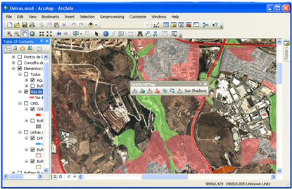
ArcGIS 10 Client |
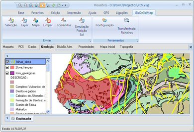
VisualSIG Client |
|
|
| |
|
|
| |
GIS clients transform a geographic layer, with its selections, legend, text and transparency, into a group of gison3dmap commands which will be send to the gison3dmap controller.
Geographical entities to be drawn by gison3dmap can be described using WKT (Open Geographic Committee Well Know Text) do OGC) strings, kml files, or be the result of an access to a shapefile, ArcSDE, SQL Server or PostGIS geographical database tables, or web map services.
gison3dmap uses a specific command language to implement client requests, such as the ones shown next:
|
|
| |
| |
DEFINELAYER Lugares_Concelho,SHP,d:\publico\u2\SHAPES\LUGARES_CONCELHO.SHP
LEGEND <?xml version="1.0" encoding="utf-16"?><LayerLegend><VectorLayerLegend><Legend BackColor="44,44,38"
...
Underline="False" Bold="False" Italic="False" /></LabelLayer></LayerLegend>
LAYER Lugares_Concelho
DRAW |
In this example, the LAYER command sends to the controller all the geographical entities that exist in the shapefile defined with DEFINELAYER, which will be projected (DRAW) rendered using the legend defined with the LEGEND command, in which a part was omitted (...).
gison3dmap projection commands can be writen to a text file by the GIS client, so that they may be later used to reproduce the same projections, from within the Powerpoint and multimedia clients. |
|
| |
^ top |
|
|